ATMS 570: Remote Sensing (Howard University)
Project 1: Using Satellite Imagery to Investigate Cyclone Titli
_________________________________________________________________________________________________________________________________________________________________________________________________________________
|
|
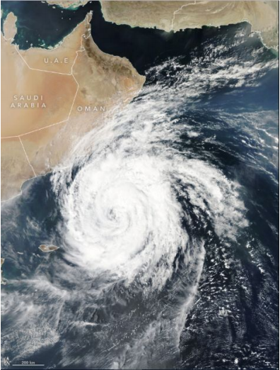
Figure 1.1: Cyclone Titli closing in on the East Coast of India on October 11th, 2018.
|
|
Figure 2.1: SNAP version of Cyclone Titli
closing in on the East Coast of India on October 11th, 2018.
|
|
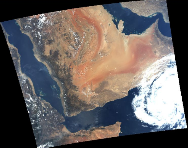
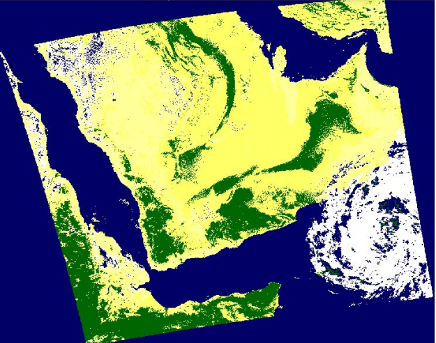
Figure 3.1: NDVI vegetation index of India
and portions of Northwest Africa.
|
|
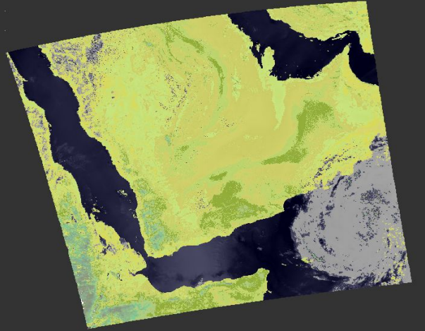
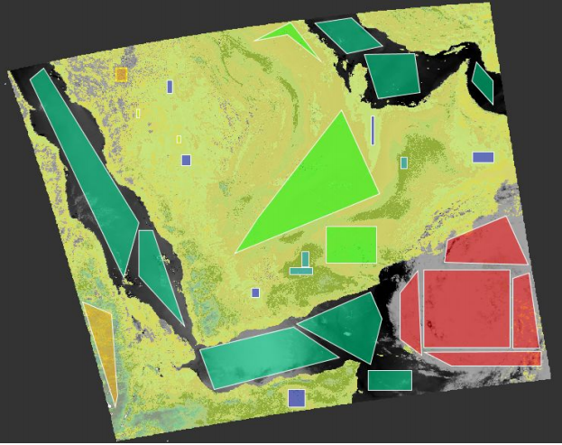
Figure 4.1: The unsupervised classification
version of India and Northwest Africa during Cyclone Titli’s lifecycle.
|
|
.Figure 5.1a: A snapshot of
defining classes for vector data,
such as water, land, vegetation, and the cyclone.
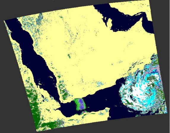
Figure 5.1b: Minimum distance supervised classification of Cyclone
Titli.
|
|
_________________________________________________________________________________________________________________________________________________________________________________________________________________
Project 2: Comparison of Cloud Top Pressure Retrieval from MODIS and AIRS sensors aboard the Aqua
Satellite over Central Indonesia
|
|
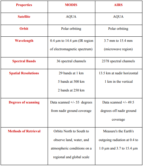
Table 1: Side-by-side information of MODIS and AIRS sensors aboard NASA’s
AQUA satellite.
|
|
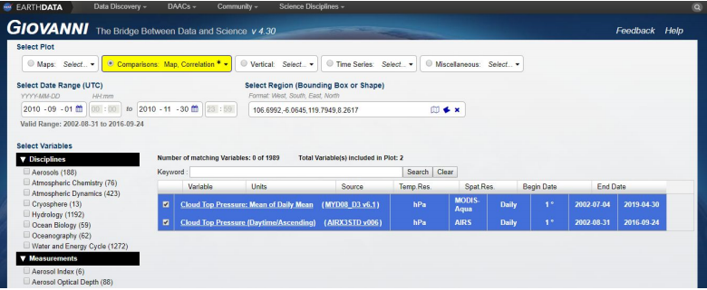
Figure 1.2: The data factors used for cloud top pressure analysis.
|
|
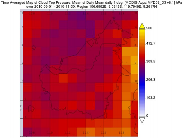
Figure 2.2a: MODIS AQUA cloud top pressure measured from 0-500 hPa from September - November for
central Indonesia. Figure 2.2b: SO2 concentration path lengths from the Mount Merapi volcanic eruptions November 4th-8th, 2010.
|
|
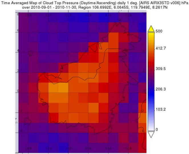
Figure 3.2: AIRS cloud top pressure measured from 0-500 hPa from September - November for central
Indonesia. Figure 4.2:
|
|
|
|
References
Baum, B.A., Menzel, W.P., Frey, R.A., Tobin, D.C., Holz, R.E., Ackerman, S.A., Heidinger, A.K. and
Yang, P., 2012. MODIS cloud-top property refinements for collection 6. Journal of applied
meteorology and climatology, 51(6), pp.1145-1163.
Nasiri, S. L., Dang, V. T., Kahn, B. H., Fetzer, E. J., Manning, E. M., Schreier, M. M., and Frey, R. A.: Comparing MODIS and AIRS infrared-based cloud retrievals, J. Appl. Meteorol. Clim., 50, 1057–1072, https://doi.org/10.1175/2010JAMC2603.1, 2011.
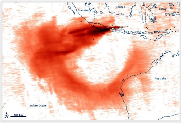
“Eruption at Mount Merapi, Indonesia.” Earth Observatory, NASA, https://earthobservatory.nasa.gov/images/46881/eruption-at-mount-merapi-indonesia
“Giovanni.” Earthdata, NASA, 5 April 2019. https://earthdata.nasa.gov/
Kahn, B. H., Irion, F. W., Dang, V. T., Manning, E. M., Nasiri, S. L., Naud, C. M., Blaisdell, J. M., Schreier, M. M., Yue, Q., Bowman, K. W., Fetzer, E. J., Hulley, G. C., Liou, K. N., Lubin, D., Ou, S. C., Susskind, J., Takano, Y., Tian, B., and Worden, J. R.: The Atmospheric Infrared Sounder version 6 cloud products, Atmos. Chem. Phys., 14, 399- 426, https://doi.org/10.5194/acp-14-399-2014, 2014.
“Report on Merapi (Indonesia) - February 2011.” Smithsonian Institute, National Museum of Natural History, February 2011. Retrieved May 1, 2019 from https://volcano.si.edu/showreport.cfm?doi=10.5479/si.GVP.BGVN201102-263250
“TERRA and AQUA Moderate Resolution Imaging Spectroradiometer (MODIS).” Earthdata, NASA, https://ladsweb.modaps.eosdis.nasa.gov/missions-and-measurements/modis/
“Urban Heat Islands.” Center for Science Education, UCAR, 2011. Retrieved May 1, 2019 from https://scied.ucar.edu/longcontent/urban-heat-islands
Nasiri, S. L., Dang, V. T., Kahn, B. H., Fetzer, E. J., Manning, E. M., Schreier, M. M., and Frey, R. A.: Comparing MODIS and AIRS infrared-based cloud retrievals, J. Appl. Meteorol. Clim., 50, 1057–1072, https://doi.org/10.1175/2010JAMC2603.1, 2011.
“Eruption at Mount Merapi, Indonesia.” Earth Observatory, NASA, https://earthobservatory.nasa.gov/images/46881/eruption-at-mount-merapi-indonesia
“Giovanni.” Earthdata, NASA, 5 April 2019. https://earthdata.nasa.gov/
Kahn, B. H., Irion, F. W., Dang, V. T., Manning, E. M., Nasiri, S. L., Naud, C. M., Blaisdell, J. M., Schreier, M. M., Yue, Q., Bowman, K. W., Fetzer, E. J., Hulley, G. C., Liou, K. N., Lubin, D., Ou, S. C., Susskind, J., Takano, Y., Tian, B., and Worden, J. R.: The Atmospheric Infrared Sounder version 6 cloud products, Atmos. Chem. Phys., 14, 399- 426, https://doi.org/10.5194/acp-14-399-2014, 2014.
“Report on Merapi (Indonesia) - February 2011.” Smithsonian Institute, National Museum of Natural History, February 2011. Retrieved May 1, 2019 from https://volcano.si.edu/showreport.cfm?doi=10.5479/si.GVP.BGVN201102-263250
“TERRA and AQUA Moderate Resolution Imaging Spectroradiometer (MODIS).” Earthdata, NASA, https://ladsweb.modaps.eosdis.nasa.gov/missions-and-measurements/modis/
“Urban Heat Islands.” Center for Science Education, UCAR, 2011. Retrieved May 1, 2019 from https://scied.ucar.edu/longcontent/urban-heat-islands